Geology of Montserrat
Dickinson College 2005
Geological Research
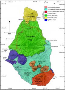
During their Geological studies on Montserrat, Dickinson students explored the island, researching lahars, pyroclastic flows, and other volcaniclastics that range from a couple of years old to 750,000 years old. Click on the stars to access further information on a particular location or refer to the links below. [Currently this feature is not working]

The above map is modified from Figure 2 from Harford et al. 2002 and from The Tourist Map of Montserrat: Emerald Isle of the Caribbean. Harford, C.L., Pringle, M.S., Sparks, R.S.J., and Young, S.R. 2002. The volcanic evolution of Montserrat using 40Ar/ 39Ar geochronology. Geol. Soc., London, Memoirs, 21. Directorate of Overseas Surveys. The Tourist Map of Montserrat: Emerald Isle of the Caribbean. 6th edition. 1:25,000. Southampton, England: British Government’s Ministry of Overseas Development, 1983.
Group 1 – St. Peter’s Hill South
Group members Kathy Adia, Andrea Alexander, Emily Bailin, and Candace Draskovich present their research on the 127.3 meter long outcrop located at the road-cut on the southern side of St. Peter’s Hill.
Group 2 – St. Peter’s Hill
Group members Katie Fox, Will Freeman, and Meg Graham showcase their research on the 75.4 meter long outcrop of the northern face of St. Peter’s Hill just south of the old stone church and Sea Wolf Dive shop.
Group 3 – Upper Fogarthy’s Hill
Group members Ashley Haywood, Alexander Lloyd, and Melissa Merel present their research on the two road-cut outcrops at the top of Fogarthy’s Hill just down the road from the People’s Place.
Group 4 – Lower Fogarthy’s Hill
Group members Dan Pattley, Karen Powroznik, and Emily Ruben present their research on the outcrop spanning the base of Fogarthy’s Hill.
Group 5 – Government Hill
Group members Tara Russell, Carrie Tate, and Kate Wetherell present their research on the outcrop named Government Hill spanning 300 meters from the newly built government buildings to the base at Carr’s Bay.
Group Work at Old Road Bay
In preparation for field work, Prof. Ben Edwards educated the students on the research techniques involved in understanding the past volcanic eruptions of the Centre Hills volcano at the Old Road Bay outcrop.
Montserrat from the Ferry
Pictures of the Emerald Isle from the ferry looking southeast onto the island.
Montserrat’s Little Bay Dock
All boats arriving at Montserrat must put in at Little Bay as a result of the destruction of the Plymouth pier. These pictures show the Caribbean side of the island as our ferry arrives on/ departs from Montserrat.
Emergency Shelters used during the Volcano Evacuation
During the first week of residence on the island, the students and professors resided in the shelters used by people displaced during the evacuations less than ten years ago. Click on the link to check out some pictures.
Bramble Airport
In preparation for research, Dickinson students explored the remains of Bramble Airport and aided by the director of the Montserrat Volcano Observatory made interpretations of the most recent eruption of the Soufriere Hills volcano.
Jack Boy Hill
On the way to Bramble Airport, the group stopped at Jack Boy Hill to take some pictures of the remains of the Bramble Airport.
Pictures of the Former Capitol, Plymouth
Click on this link to see pictures from an excursion into the city of Plymouth.
Group Picture in the Belham River Valley
What was previously a golf course has now been turned into a flood/lahar plain for the Belham river. In the past couple years significant amounts of unconsolidated volcanic ash have been deposited in this valley burying what was formerly there and acting as a major hinderance to returning to the bottom half of the island.
Group and Panoramic Pictures from the Summit of St. George’s Hill
Before venturing into the remains of Plymouth, students ascended St. George’s Hill to take some photographs of the former capitol city.
Pictures of the Soufriere Hills Volcano from the Montserrat Volcano Observatory
On a clear day, the Montserrat Volcano Observatory (MVO) can serve as a great observation point for surveying the Soufriere Hills volcano and its surrounding topography currently in the exclusion zone.
Other Resources for the Geology of Montserrat
Return to Geology and Sociology of Disasters Homepage
Geology at Dickinson College
Sociology at Dickinson College
Ben Edwards PhD., Assistant Professor of Geology
Dan Schubert PhD., Associate professor of Sociology Department Chair
Geology 311/Sociology 230