40-50 Million Years Ago: Collision between Indian and Eurasian Plate
1255: First recorded earthquake in Nepalese history
August 15th, 1950: Assam- Tibet Earthquake
January 15th, 1934: Nepal- Bihar Earthquake
September 18th, 2011: Sikkim Earthquake
August 21st, 1988: Nepal- India Earthquake
April 25th, 2015: Gorkha Earthquake

Timeline of 2015 earthquake events: http://www.telegraph.co.uk/news/world/china-watch/society/nepal-earthquake-timeline/
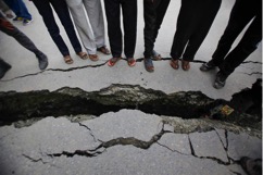
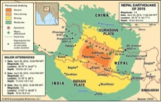
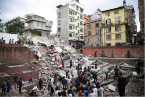
One of the biggest events in recent Nepali history is the Gorkha Earthquake, which occurred on April 25th, 2015. It struck the capital city of Nepal, Kathmandu, around 11:25 am and had a magnitude of 7.8. The earthquake was felt throughout Nepal, Bangladesh, India, Bhutan, and Tibet. Approximately 9,000 people were killed, with thousands more injured and several million displaced, as nearly 600,000 structures were degraded to rubble. The earthquake also resulted in aftershocks within the next few hours and days, causing additional damage (Rafferty).

Because the Himalayas are a highly seismically active area, lying along the Indian and Eurasian plate boundary, high magnitude earthquakes have previously been common throughout history. The last major earthquake took place in 1988, with a magnitude of 6.9. However, there were several notable others, including a 8.0 magnitude earthquake in 1934, which killed nearly 2,000 people (Rafferty).
Extreme damage was caused a result of the 2015 earthquake. Along with the structural devastation, the quake triggered thousands of landslides throughout rural Nepal and Kathmandu, devastating once-bustling areas. It also caused an avalanche on Mount Everest killing 19 climbers (Rafferty).

Massive assistance was needed to aid Nepal, both physically and financially. Immediate damage costs were estimated to be about 5 to 10 billion dollars, with thousands of hours of cleanup required. The international community, through the United Nations, provided financial assistance by setting up a relief fund for Nepal raising several hundred million dollars within hours (United Nations). According to their website, USAID also provided assistance on behalf of the United States through a Disaster Assistance Response Team (DART), which coordinated efforts to conduct disaster assessments, search and rescue deployments, and assist with safe food, water, and shelter (2015 Nepal Earthquake).
This event is extremely relevant to our course. While the earthquake itself may not be directly linked to climate change, it is the most prevalent example of how Nepal has responded to an extreme weather event in the past and how they might respond in the future. It is also likely that this will be a frequent topic of conversation during our interviews, therefore, we should be informed and empathetic on the topic. In addition, despite the passage of time, Nepal is still far from a full recovery. Therefore, we will likely see some the structural destruction and recovery efforts throughout our travels, particularly in rural areas. Additionally, it is important to understand their relationship with foreign aid and how we might trigger different responses as westerners.
Interactive map: http://www.bbc.com/news/world-asia-32479909
Sources:
Hart, Tom. “Nepal: A Timeline of Tragedy – Geographical.” Geographical Magazine, 28 Apr. 2015, geographical.co.uk/nature/tectonics/item/1000-nepal-timeline. Accessed 9/10/17.
Rafferty, John P. “Nepal Earthquake of 2015.” Encyclopædia Britannica, Encyclopædia Britannica, Inc., 24 Apr. 2017, www.britannica.com/topic/Nepal-earthquake-of-2015. Accessed 9/10/17.
“UN Allocates $15 Million in Emergency Funds for Nepal Earthquake Response.” UN News Center, United Nations, 28 Apr. 2015, www.un.org/apps/news/story.asp?NewsID=50708#.WbXMztN940o. Accessed 9/10/17.
“2015 Nepal Earthquake.” U.S. Agency for International Development, www.usaid.gov/nepal-earthquake. Accessed 9/10/17.
